


The Legacy of the Losers
Preserved in a Forgotten Medieval Gold Mine
Red relief maps reveal vast artificial slopes created by medieval mining activities.
Published March 1, 2026
Introduction
For decades, the true scale of mining at Yu-no-oku remained hidden in plain sight.
Researchers had mapped the area using traditional contour maps during surveys conducted between 1989 and 1991. These maps recorded elevation with precision, but they could not fully convey the subtle textures of the mountainside. The terrain appeared complex—but not extraordinary.
That perception changed with the application of the Red Relief Image Map (RRIM).
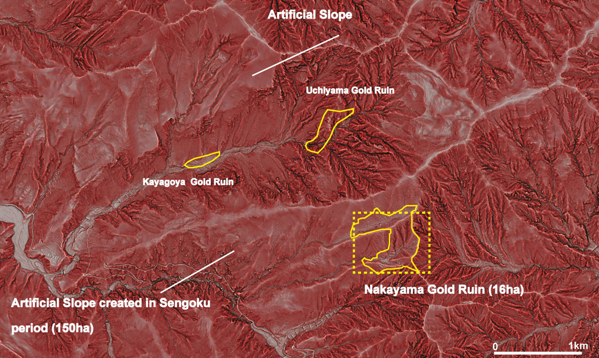
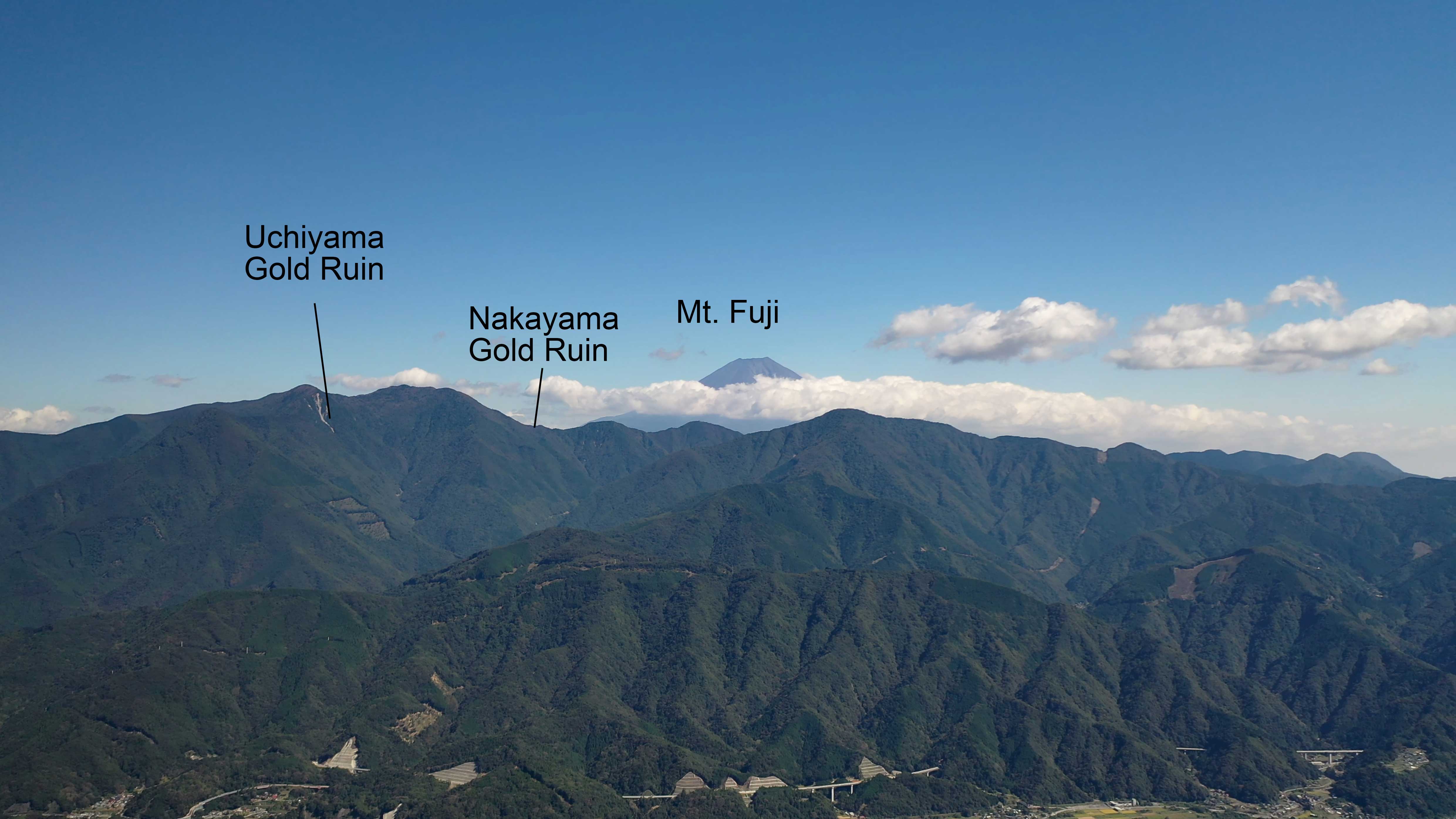
The modified slopes extend approximately 2 kilometers from east to west and 1.3 kilometers from north to south, covering nearly 150 hectares—almost ten times the area officially designated as a National Historic Site at Nakayama.
Red Relief Image Map — When the Mountain Revealed Its Secret —
RRIM is a high-resolution terrain visualization method that combines slope gradient and surface curvature. Instead of simply connecting points of equal elevation like a contour map, it renders ridges in white, valleys in black, and steep slopes in vivid red. Subtle variations in landform—barely noticeable in conventional mapping—suddenly become visible at a glance.
When RRIM was applied to the Yu-no-oku Gold Mining Ruins at a horizontal resolution of 25 centimeters, the mountain’s hidden structure became visible.
What had seemed like natural terrain revealed itself as an engineered landscape.
Across the slopes of Nakayama and Kayagoya, vast artificial terraces emerged clearly in white tones, contrasting sharply with the darker, irregular forms of surrounding natural valleys. Linear features—likely remnants of old roads—became visible for the first time.
The geometry of the land was no longer accidental; it was deliberate.
At Nakayama, archaeological evidence—including pottery dating to the late 15th century—clearly indicates that the artificial terraces were constructed during the Sengoku period.
In contrast, the slopes identified near the Kayagoya and Uchiyama sites have not yet undergone detailed archaeological investigation due to their remote and steep terrain. While their morphology strongly resembles that of Nakayama and suggests a similar period of construction, definitive dating awaits further field research.
These were not minor adjustments for small-scale mining. They represent one of the largest surviving examples of medieval mountain engineering in Japan.
RRIM did not merely produce a clearer map. It revealed that the mountains themselves had been reshaped.
What is Yu-no-oku?
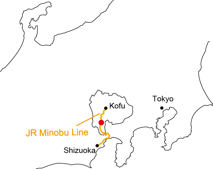
The JR Minobu Line, which connects Kofu station and Shizuoka station, runs through a valley between Mt. Fuji and the Southern Japanese Alps. This mountainous region contains many historical sites dating back to samurai-era Japan.
The Yu-no-oku Gold Mining Ruins are a collective term for three mining sites—Nakayama, Kayagoya, and Uchiyama. These gold mining ruins are located on the slopes of Mt. Kenashi, where the nearest station is Shimobe-Onsen station in the JR Minobu line.
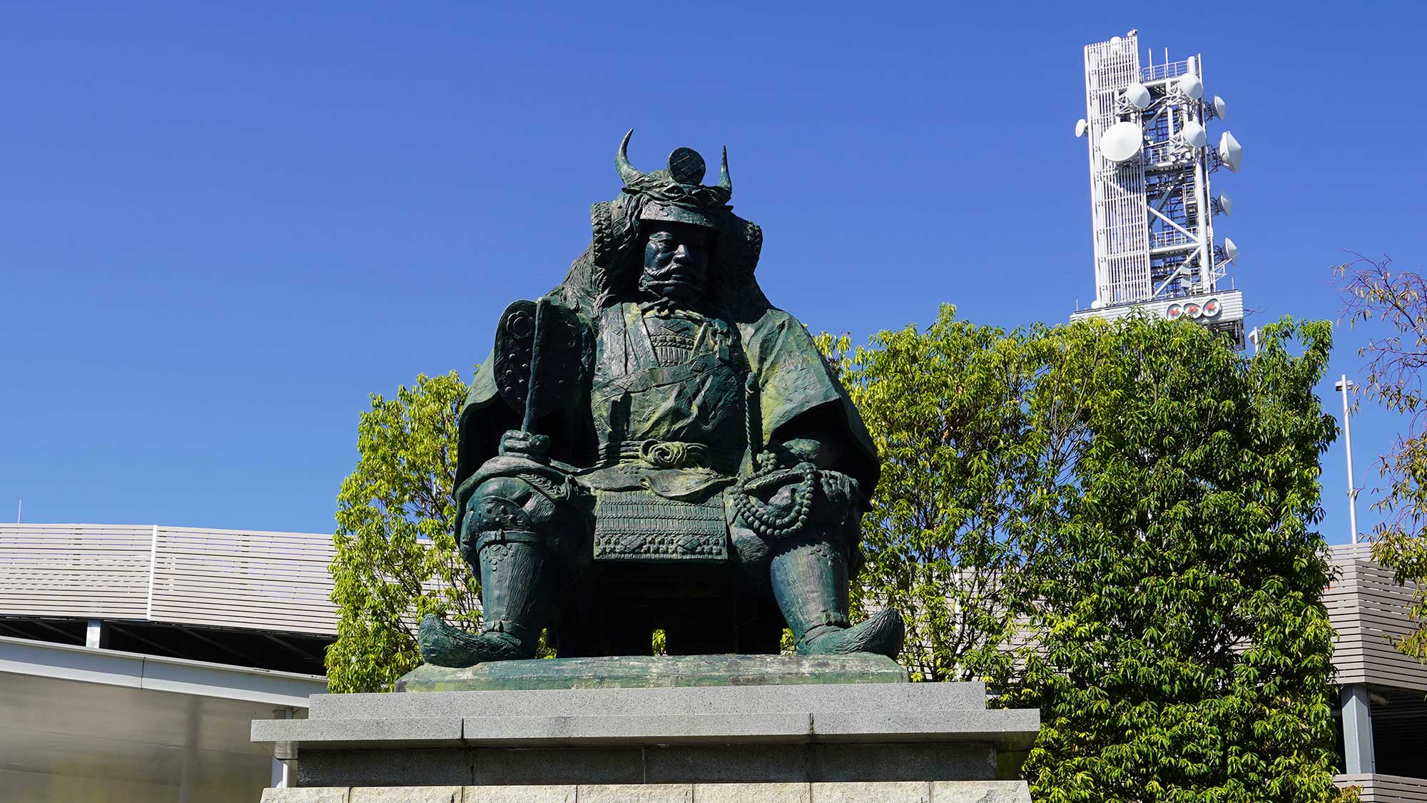
During the Sengoku period, this region was governed by Shingen Takeda, one of the most powerful samurai warlords of the time. In addition to his renowned cavalry forces, Shingen is also known for actively developing gold mining as a key economic resource. In this context, the Yu-no-oku gold mine was administered by Nobutada Anayama, a trusted retainer and one of the Twenty-Four Generals of Shingen Takeda.
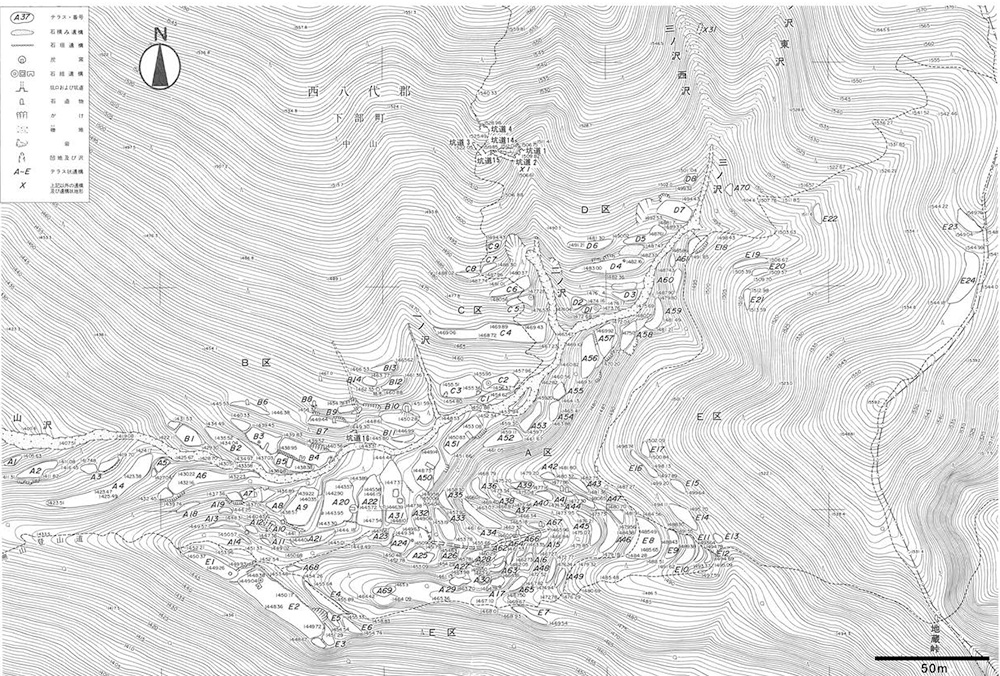
For many years, local legends claimed that this region contained a hidden gold mine controlled by Shingen Takeda. Based on these traditions, comprehensive academic research was conducted between 1989 and 1991, combining field surveys with analyses of historical documents. The Nakayama Gold Ruins is located on steep mountain slopes at elevations exceeding 1,500 meters, in an area completely uninhabited today.
During the investigation, researchers endured physically demanding conditions: they camped on the mountainside for a few days at a time, then descended to the village at the foot of the mountain for a brief rest before returning to the site. This cycle was repeated throughout the survey period.
What was found?
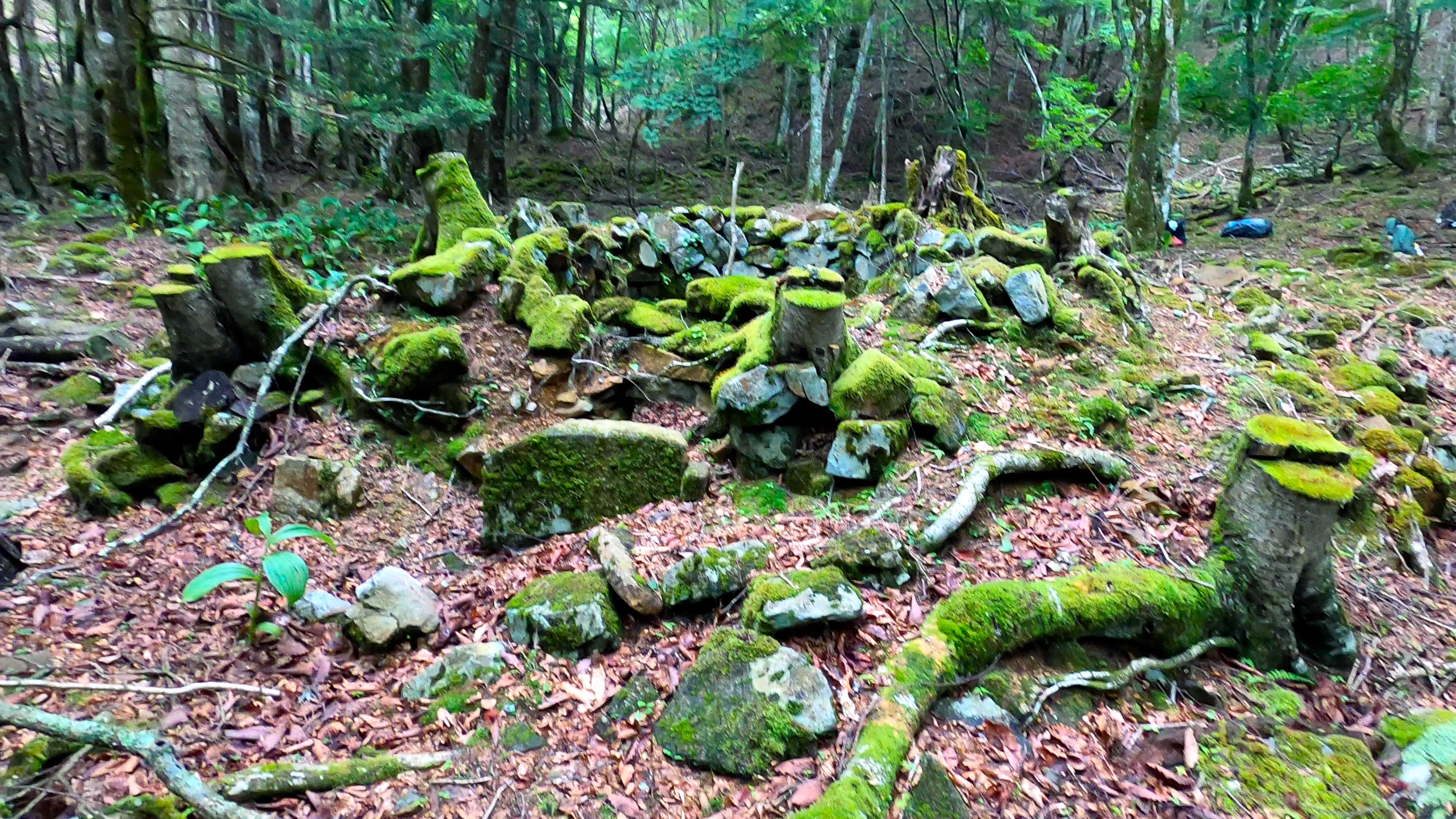
As a result, the Nakayama Gold Mine was found to consist of 124 terraced platforms, 77 open pits, and 16 mine shafts carved into steep mountain slopes. Numerous artifacts were also discovered, including stone mills, masonry structures, stone monuments, pottery, slag, coins, and smoking pipes. Notably, Nakayama preserves one of the earliest surviving forms of mine shafts in Japanese history.
Based on these findings, the area of 16 hectares at the Nakayama Gold Mine was designated a National Historic Site of Japan in 1997, recognized for its well-preserved evidence of medieval mining development and the daily lives of mining workers.
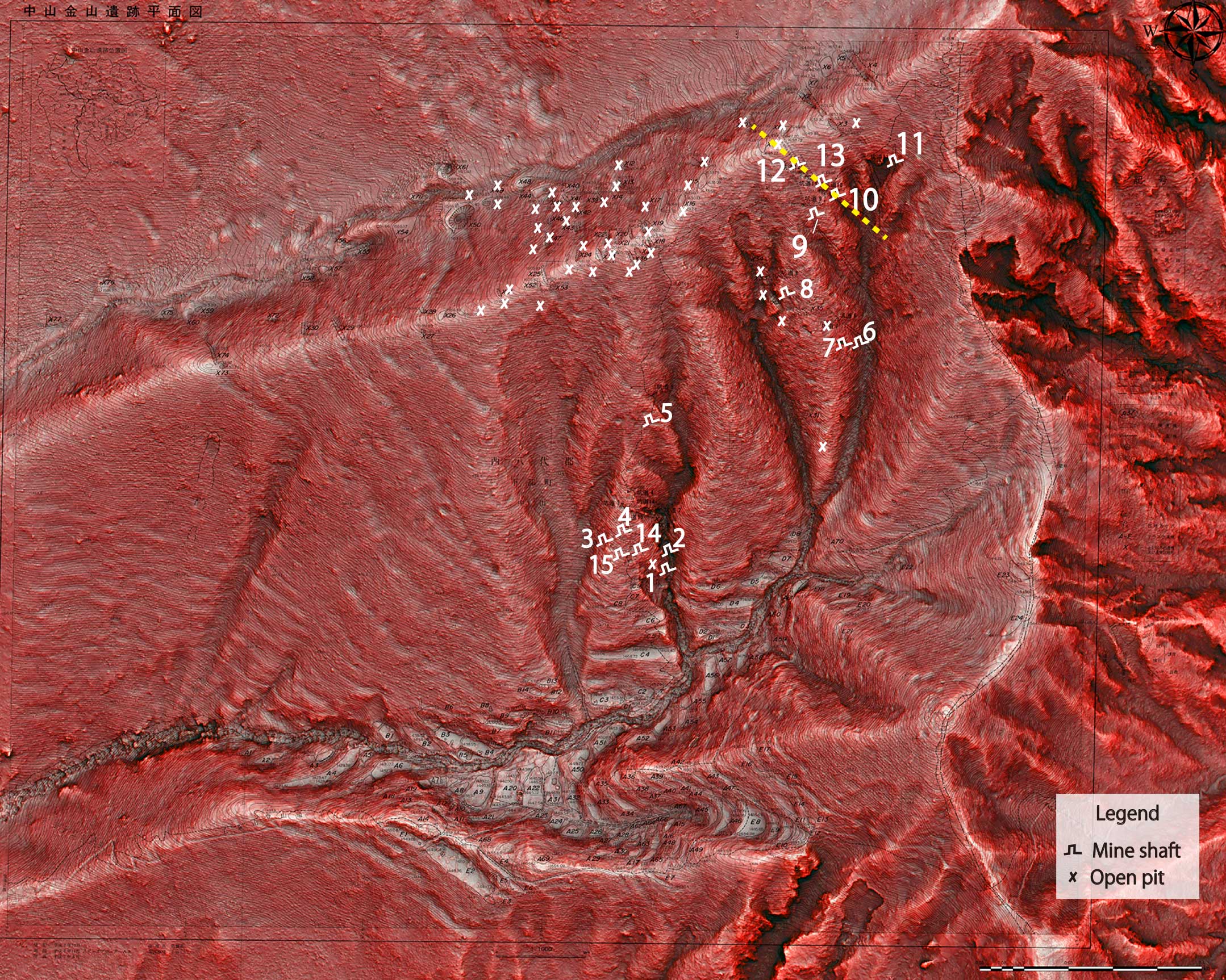
Artificial terraces are shown in white, valleys in black, and the old road in dark gray.
Historical background
It has been revealed that the Yu-no-oku Gold Mine was actively operated during the Sengoku and early Edo periods, reaching its peak in the Sengoku period (15th–16th centuries). The Sengoku period was marked by frequent civil wars, as powerful samurai leaders—known as daimyo—competed for territorial control and political dominance.
During this era, many daimyo sought to unify the country and actively adopted new technologies introduced from Europe during the Age of Discovery. Gold and silver mining became increasingly important, serving not only as domestic currency but also as a means of international trade to acquire firearms and other military equipment.
Shingen Takeda (1521–1573) was one of the most powerful daimyo of this period and ruled Kai Province, corresponding to present-day Yamanashi Prefecture. Known as the “Tiger of Kai,” Shingen was regarded as a formidable rival to Nobunaga Oda, a central figure in Japan’s unification.
Tokugawa Ieyasu, who later established the Edo Shogunate in 1603, initially served under Nobunaga Oda. In 1573, Shingen Takeda defeated the combined forces of Nobunaga and Ieyasu at the Battle of Mikatagahara, inflicting heavy casualties. Shingen’s military power posed a serious obstacle to Nobunaga’s unification efforts.
Shingen Takeda is also remembered for his famous words:
“People are castles. People are stone walls. People are moats.
Kindness is a friend. Hatred is an enemy.”
He was deeply influenced by Sun Tzu’s Art of War, and his battle standards bore the well-known phrase:
“Swift as the wind, silent as the forest, fierce as fire, and immovable as the mountain”
(Fūrinkazan, 風林火山).
Kai Province faced significant geographical disadvantages. Surrounded by mountains, it had no access to the sea and only limited arable land. Under such conditions, gold mining became a crucial financial resource. As a mountainous region rich in mineral deposits, Kai Province contained several productive gold mines, among which the Yu-no-oku Gold Mine and the Kurokawa Gold Mine were particularly important in sustaining the regional economy.
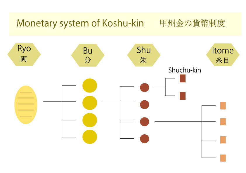
Another important legacy of Shingen Takeda was the establishment of one of Japan’s earliest standardized monetary systems, known as Kōshū-kin (甲州金). While many daimyo minted gold coins whose value was determined solely by weight, the Kōshū-kin system employed a quaternary unit structure. This system later influenced the monetary framework adopted by the Tokugawa Shogunate after 1603.
The Yu-no-oku Gold Mine played a central role in supporting this monetary system, functioning as a flagship gold production site within Kai Province.
The region containing the Yu-no-oku Gold Mine was known as the Kawachi region, which accounted for approximately one third of the total territory of Kai Province. Historical documents indicate that this region was governed by Nobutomo Anayama and later by his son Nobutada Anayama. Nobutada’s mother was Shingen Takeda’s elder sister, and he later married Shingen’s daughter, placing the Anayama family among the most influential lineages within the Takeda clan.
Shingen Takeda died of illness in 1573, leaving the leadership of the clan to his son, Katsuyori Takeda. Unlike his father, whose life ended by natural causes, Katsuyori met a tragic fate. In 1575, Nobunaga Oda launched a major campaign against the Takeda, culminating in the Battle of Nagashino, where Katsuyori suffered a decisive defeat. In the aftermath of the battle, Nobutada Anayama defected from the Takeda clan and began supplying intelligence to Tokugawa Ieyasu and Nobunaga Oda, a betrayal that accelerated the rapid collapse of Takeda power. Ultimately, in 1582, Katsuyori took his own life, bringing the Takeda clan’s rule to an end.
After Katsuyori’s death and the fall of the Takeda clan, many of skilled mining engineers from Kai Province were recruited by Ieyasu Tokugawa. Their expertise in gold mining and mine management was subsequently transmitted to other regions, forming an important part of the technological foundation of early Edo-period mining.
Geological setting
The mountains surrounding Yu-no-oku are not ordinary mountains. Around 14 million years ago, the mountains were not part of Japanese Honshu island at all, but volcanic islands rising from the deep sea. Beneath these submarine volcanoes, hydrothermal fluids circulated through fractured rock, depositing gold and other metals on the ocean floor.
Millions of years later, around 5.4 million years ago, renewed magmatic activity reshaped the region. As magma intruded upward, it reheated the surrounding rocks, and gold-bearing fluids crystallized within fractures, forming the quartz veins that would one day be mined at Yu-no-oku.
The gold that later sustained samurai warlords was born through these two episodes of volcanic activity—first beneath an ancient ocean, and later within rising mountains.

The Hidden Engineers of the Mountains
Behind the gold of Yu-no-oku stood a specialized group known as the Kinzan-shu—literally, “the gold mine corps.”
They were far more than prospectors. The Kinzan-shu were skilled engineers who understood not only how to locate and extract gold, but also how to reshape entire mountainsides. Maintaining open pits and carving mine shafts into steep terrain required advanced knowledge of slope stability, drainage, and large-scale earthworks.
A historical record from 1571 offers a remarkable glimpse of their capabilities. Ten members of the Kinzan-shu from Nakayama were reportedly mobilized during a military campaign against the Hojo clan at Fukasawa Castle. Within approximately thirty days, they dismantled sections of the castle’s defensive slopes—steep, artificially cut embankments designed to prevent enemy assault. The same technical expertise required to excavate gold veins could also be applied to warfare.
The vast artificial terraces revealed by RRIM suggest that Yu-no-oku was not a minor mining site, but a major center of organized mountain engineering during the height of the Takeda clan’s power.
After the fall of the Takeda in 1582, many of these skilled engineers were absorbed into the emerging Tokugawa regime. Their knowledge of mining and landscape modification would later contribute to the technological foundation of early Edo-period resource development.
By the late 17th century, however, historical documents record a decline in gold production at Yu-no-oku. The Kinzan-shu gradually disappeared from local records, likely relocating to more productive mines elsewhere in Japan.
What remains today are not only abandoned shafts and terraces—but the silent traces of a highly organized engineering community that once transformed entire mountains in pursuit of gold.
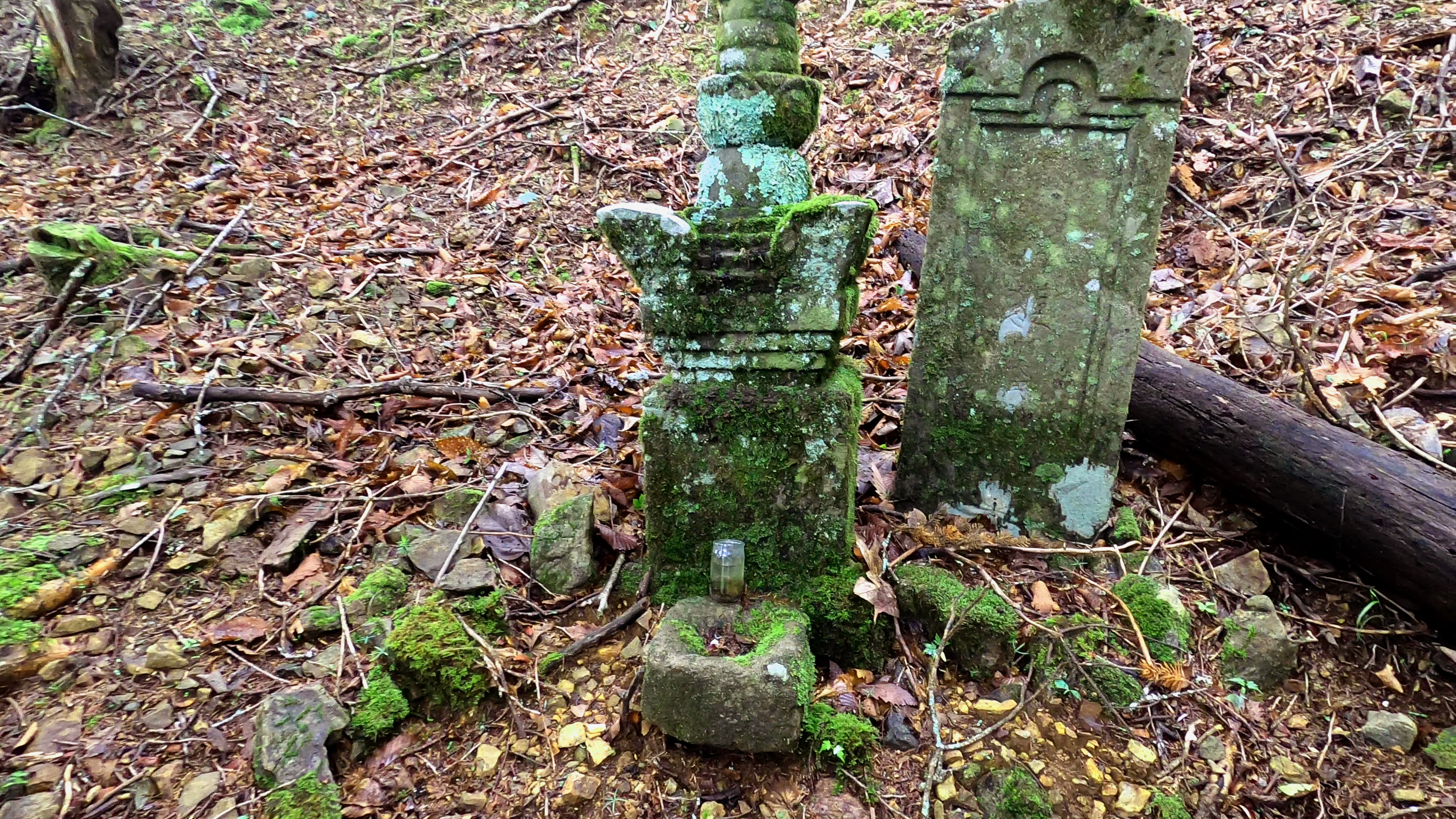
Carved inscriptions commemorate those who once worked—and died—at the gold mine.
References
Omata, T., Komatsu, M., Chiba, T., Igari, S., Suzuki, T., Ito, K.,
Hayashi, T., Kumagai, K., Tanaka, K., and Kido, Y., 2025,
Evaluation of the Technology in the Historical Artificial Slopes
and Mining Development Based on the Red Relief Image Map in the
Yu-no-oku Gold Mining Ruin (in Japanese),
Geoinformatics, v.36, n.3, p.53–63.
DOI:
10.6010/geoinformaticsx.36.3_53